Explore Our Diverse Range of Projects
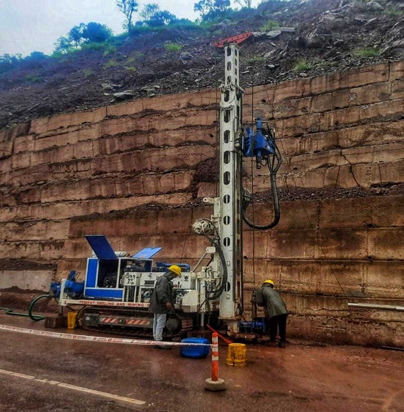
Geotechncial Investigation
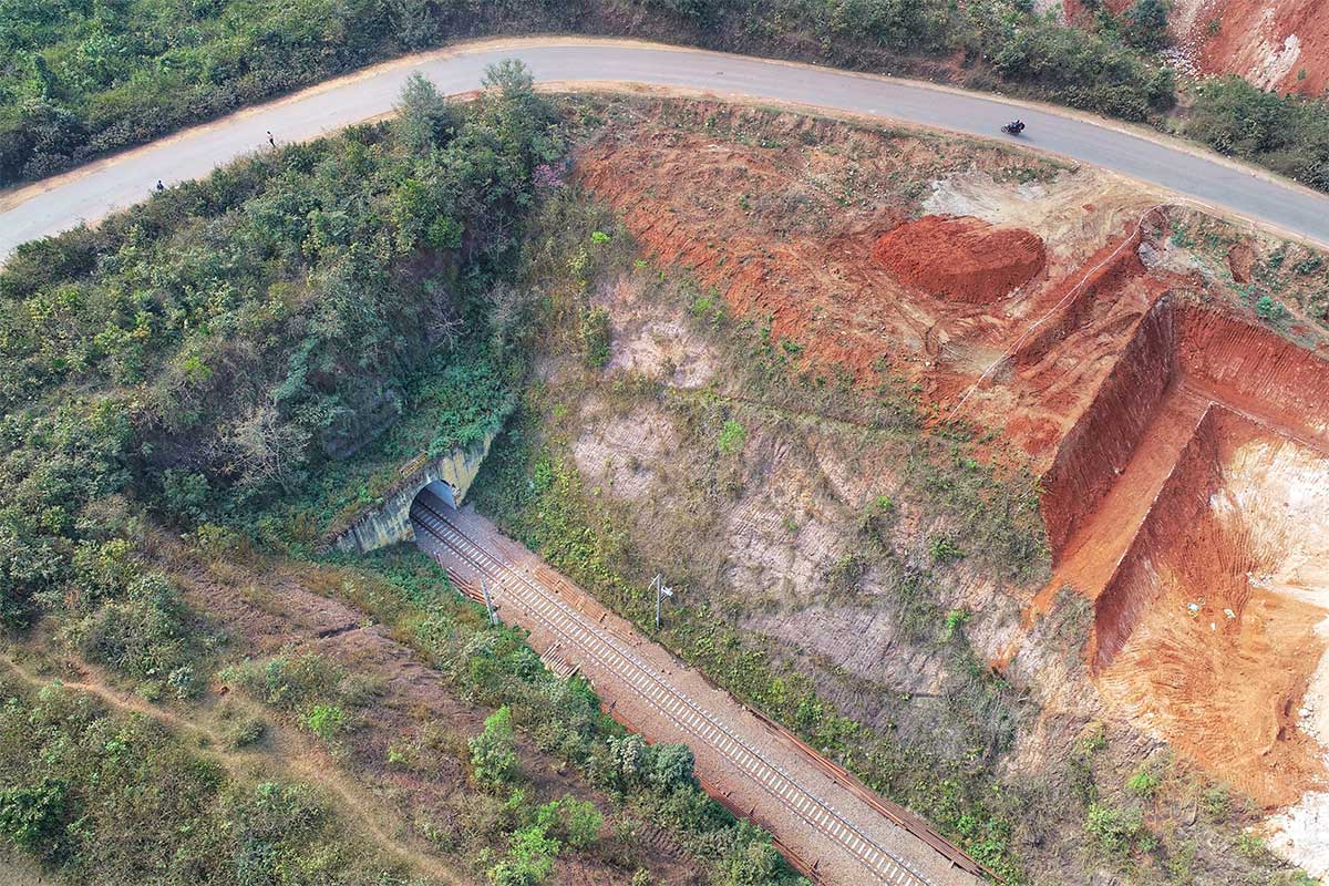
- Geotechnical Investigation and Preparation of Detailed Geotechnical Report for Various Locations of Tunnel alignment for Pune - Nashik Semi High - Speed Rail Project – Tunnels 1 to 7 between Ch. 214.100 to Ch. 264.860
- Geotechncial Investigation for multiple structures like Runway Extension, Passenger Terminal Building, Multilayer Car Parking, Precision Approach Lighting at Mangaluru Intl Airport
- Geotechnical Investigation work for Chemical Plant at LPG Phase-II at JSW Jaigarh Port Ltd.
- Conducting Geotechnical Investigation Works for FGD Package of Wanakbori Thermal Power Station (1X800 MW),GSECL.
- Conducting Geotechnical Investigation at WNA (Weak Nitric Acid) unit of GNFC Bharuch, Gujarat, India for Gujarat Narmada Valley Fertilizers & Chemicals Limited
- Geotechnical Investigation at Navi Mumbai International Airport Project
- Geotechnical Investigation for Instrumentation for Shri Ramjanmabhumi Temple Project, Ayodhya
- Geotechnical investigation - Nagpur Mumbai Samruddhi Expressway Project (Ch. 469.139km to Ch. 493.511km)
- Conducting Geotechnical Investigation for quarry at various locations along Wapi to Mumbai Section of Bullet Train Project.
Geophysical Investigation
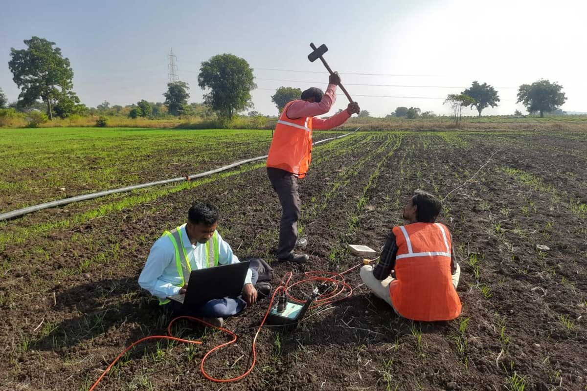
- Geophysical Investigation (ERT and SRT) for proposed Railway Line from Raxaul to Kathmandu.
- Geophysical Investigation for Bridges at Rangpo - Ranipool stretch Sikkim
- Geophysical investigation to suggest remedial measures for arresting leakage around TP-1 at SSTPP, Stage-I, Dongalia Distt. Khandwa.
- Geophysical Investigation around Tunnel-10 (T4-02), Mandi Himachal Pradesh
- Geophysical Investigation by Conducting Electrical Resistivity Test (ERT), Seismic Resistivity Test (SRT) and MASW for Leakage Study and strength of Bhimtal Dam, Nainital
Geospatial Investigation
- Geological Mapping, Drone Survey and Geophysical Investigation (ERT & SRT) at tunnel locations for Upgradation/ Strengthening of Existing Two/ Four Lane Carriageway to Four Lane Divided Carriageway in Naswade, Netrang Taluka Section of NH-56 in the State of Gujarat on Hybrid Annuity Mode (Package IV)
- Geological Mapping, Drone Survey for "Construction of Missing Link with Viaduct from Km 0+000 to 13+300 & Up-gradation to 8 lane from Km 32+800 to Km 38+700 under Capacity augmentation of Mumbai - Pune Expressway in the state of Maharashtra Under EPC Mode (Package 02)".
- Drone Survey for Landslide area near Tawang Monastery, Arunachal Pradesh
- Drone survey & Geological mapping for design of slope stabilization measures between MHDA-SGRL chainage 1337.20 to 1340.625 km of Katni-Singrauli Rail Doubling project of ECR section
- Drone Survey for Four Laning of Solan to Kaithlighat of NH-22(now NH-05)under NHDP Phase-III on EPC mode pattern in the state of Himachal Pradesh.
- Drone Survey for Conducting Slope stability analysis of deep cuttings and slopes of major bridge locations, land slide areas, Design/suggestion for stable slopes and submission of scheme for remedial measures to protect deep cutting, Design of RCC retaining wall on open and deep foundation, subsurface drainage, covered drains etc. from Ch 0.575 to Ch 51.30 in connection with construction of Bairabi- Sairang New BG line Project.